On multiple occasions, my intended drone flight was defeated because my DJI drone refused to spin-up the propellers. Although the flight is authorized by the FAA, the drone refuses to launch. With proper planning, this problem is avoidable.
DJI drones include a safety feature known as Geofencing, which is intended to prevent flying in areas that are could be unsafe, particularly near airports. There are different systems of understanding the airspace and the DJI system is entirely different that the system employed by the FAA.
Local airport facility grid
Anywhere around controlled airspace, maximum flight altitude is determined a grid layered across a map; each grid-square indicates maximum altitude. As this is local to the facility/airport, it is commonly referred to as the facility grid.
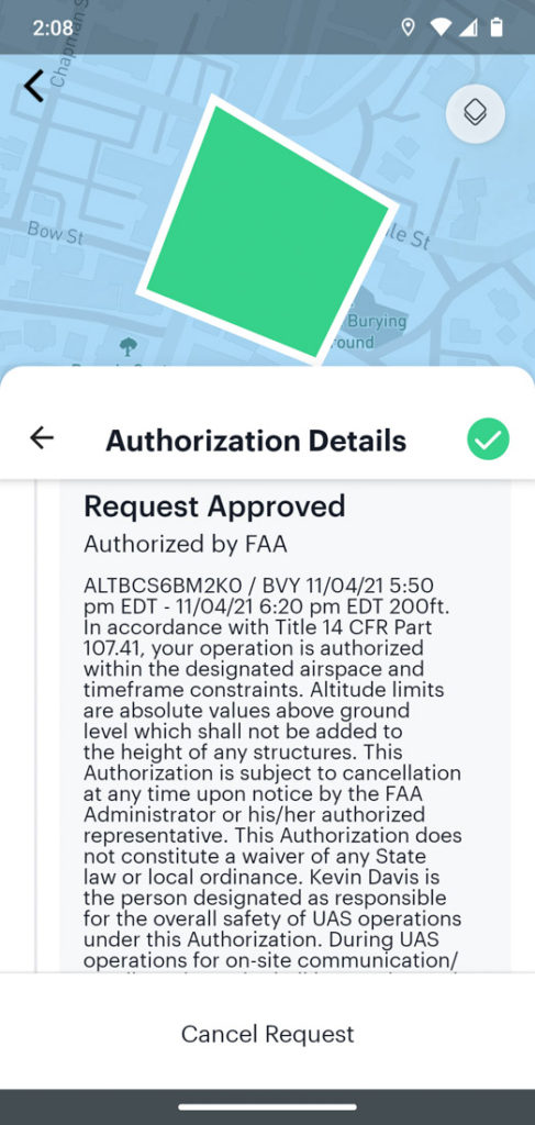
A flight plan that does not exceed the stated maximum altitude can often be approved in seconds by a computer, without need for review by a person. This is made possible by a computerize system called LAANC (low altitude authorization). Submit your flight plan via a mobile app that supports LAANC. If you succeed in receiving authorization, you may need to export that information and then submit it to DJI to unlock your drone.
For years, I used a LAANC-enabled app called AirMap. Recently, that failed (and I found some rumors online why that might be true). Ultimately, I was forced to switch to a different LAANC-enabled app and I now use Aloft (https://www.aloft.ai/), formerly known as Kittyhawk.
If your drone is locked and will not launch, flight authorization from the FAA – by itself – does not unlock a DJI drone.
DJI Geofencing
Based upon the current GPS location, the drone automatically is aware of local flight restrictions. Potentially, it can refuse to take off. In some cases you may be able to unlock it from your flight controller; this is called self-unlocking. In other cases, self-unlocking is not allowed and you must request unlocking DJI Fly Safe (https://www.dji.com/flysafe). FAA flight authorization is a prerequisite.
In advance of your flight, always check the DJI Fly-Safe geofencing map. If you’re flight is either fully or partly in a blue zone or red zone, you will need to manually unlock the drone. DJI GEO system shows approach paths to airport runways and it is these areas that are likely to be considered no-fly zones. DJI did not invent this system; it is based upon LATAS (Low Altitude Traffic and Airspace Safety), which I have read was pioneered by PrecisionHawk.
Do not wait until you arrive at your launch location before checking that your drone will be able to launch. Research in advance: weather, FAA controlled-airspace restrictions, NOTAMs, and DJI GEO restrictions.
In specific geographic locations, your drone controller may display “NFZ”, which means “No-fly Zone”. When locked due to a NFZ, the drone can only be unlocked via the DJI Flysafe website; it cannot be unlocked via self-unlocking.
(I remember a conversation with a police officer in Boston when he asked to check my flight authorization. When I told him the drone would not launch in a specific location, he suggested that the pilot can simply unlock it and I told him that is not always true. Clearly this guy does not have personal experience flying DJI drones within the class-B airspace of Boston Logan airport.)
On mobile devices (e.g. smartphone), the Fly-Safe website reports that unlocking is not supported on the mobile website. The solution is to use a full-screen computer. Do this at home before you drive off to your launch site.
For custom unlocking via the DJI Flysafe web page, you probably need a computer.
Upon submitting your request, two things happen. You will receive an email that states “Unlock application is created.” The web site shows you that the request is “Pending review.”
If all goes well, two things will happen. You will receive a subsequent email within less than 10 minutes stating “Unlock application is accepted.” The website shows you that the request is “Accepted.”
Your login username must match: Flysafe web site & the mobile app.
Import the unlock certificate to the aircraft
What happens next is not entirely obvious and requires a bit of care. You launch the app for piloting (e.g. DJI Go 4 or DJI Fly) and find the menu item “Unlocking License” (DJI Go 4 app) or “Unlock GEO Zone” (DJI Fly app). The app retrieves any unlocking authorizations via the Internet. This requires two things. You must be connected to Internet data (e.g. Wi-Fi or cellular data network). Whenever you launch the app, you must be logged-in and the username must match the username that you used when requesting the unlock. (I have once stumbled because I had inadvertently used a different login, the unlocking license could not be found, and my intended flight did not happen until after I solved the mystery.)
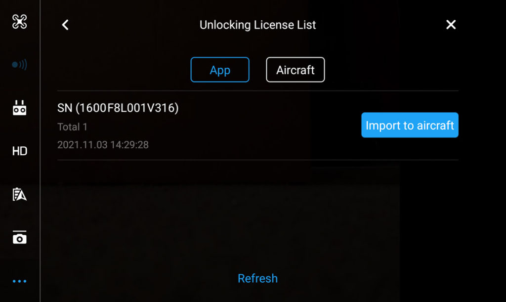
If all goes well, your unlocking authorization will be listed. You’re not quite done yet; there are two more steps to unlock the drone. Though the license is recognized by the remote controls, the license must be copied to the drone. Look for “Import to Aircraft”. Do that and the app will then show that the drone has the license and it appears with a on-screen enable/disable switch. As the default is “disabled”, you must slide it to “enable” before the drone will finally unlock the NFZ. The display on remote controller will change from “NFZ” to “Ready”.
NOTAMs (Notice to AirMen)
Mobile apps that support LAANC will show you both the boundaries of controlled airspace (class-B, class-C, class-D, class-E ground level) and all local facility grids. However, most of these apps do not show active NOTAMs. To see active NOTAMs, simply look at Skyvector.com. Active NOTAMs appear as red circles.