Update Regarding Aerial Drones (sUAS) in the U.S. – October 7

I have relied upon an aerial drone for photography and video, for both real-state assignments and publishing projects. Other folks use aerial drones for agriculture, structural (e.g. bridges) assessment, search & rescue, etc.
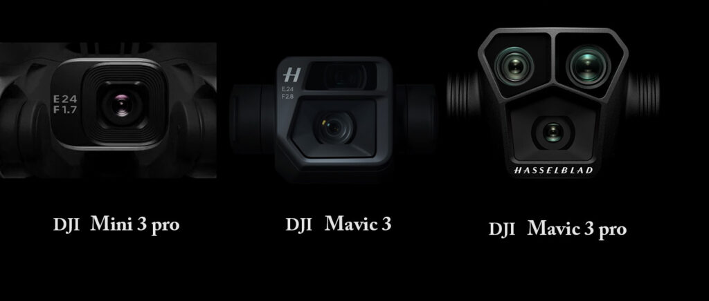
The dominant provider of commercial and recreational drones has been DJI (a Chinese company) and any alternative providers do not provide the same value at similar price points. Furthermore, we’ve seen multiple companies introducing new applications for aerial drones, including deliveries and transportation.

In the United States, existing uses of aerial drones have faced some disruption in 2025.
(a) Imports of some DJI products have been blocked by US Customs & border protection
(b) Tariffs on imports (notably imports from China)
(c) Pending ban on drones made in specific countries (e.g. China, which includes DJI, Autel Robotics, and others)

The reasons for (a) are muddled but seems a combination of factual bad actors (dating back to 2019) and distrust of specific foreign governments (e.g. China).
The import problem is not directly related to tariffs.

As for (c), the drone ban, this stems from legislation passed by Congress in 2024, which requires the United States government to somehow demonstrate that foreign drones (particularly DJI) are either a threat or not; and if the government fails to do so, then the answer will be assumed to be “threat.” As of October 1, 2025, the government has failed to act or chosen to not act.

If the ban goes into effect (end of this year), there can be several possible consequences.

  1. Imports from specific manufacturers, notably DJI, will be prohibited
  2. Manufacturers such as DJI cannot provide warranty support (including DJI Care) for previously sold products
  3. Unclear if existing drones might be grounded, which would impact hundreds of thousands of businesses including agriculture and law enforcement.
  4. Unclear if the ban might include both commercial uses and recreational uses

Upon reading House amendment to the Senate amendment to H.R. 5009 (Dec.7,2024)

  • * The Secretary of Defense shall fully disassemble a drone aircraft made by DJI or a similar … in order to create a taxonomy for each component
  • * Secretary of Defense shall submit … a report

Possibly the Dept. of Defense has begun this effort, but no one has reported any hint that might be true.
The primary concerns are:

  1. Specifically, military uses (and perhaps civil authority uses) must not rely upon (untrusted) foreign sources.
  2. For any drone/sUAS, increase resiliency of supply chain using parts supplied by domestic sources.
    This is anticipating that aerial drones will increase (deliveries, transportation, etc.) and the technology supply chain need be secure.
  3. In particular, the Chinese government reserves the right to seize any information they want from private companies (including DJI and Autel), which gives rise to general concerns of spying, though no one can identify any specific seizure that might pose a threat to the United States.

Today, there is no American drone manufacturer value and price comparable to the market leader, DJI. (Autel Robotics was a potential contender but is also a China-based company and has been greatly hindered since the U.S. government included the company on their list of concerns.)
largely, legitimate commercial drone use has no alternative to DJI. This may suggest a slow transition (not hard cut-off ban) as American companies step up. At the end of 2025, what exactly will happen remains uncertain and remains a concern for numerous commercial uses. In the meantime, several companies have emerged that sell DJI drone clones, presumably licensed by DJI as they are attempting to work around the impeding ban.

Afternoon Paddle on the Ipswich River

For an afternoon paddle that day, I considered a few options from Middleton to Ipswich. I loaded my canoe atop my car, tied it down, then drove to the boat launch at High Street.

Having paddled here a few times before, I knew well that a wrong turn can easily lead down the Beverly-Wenham Canal.  After using a maps app on my smartphone to double-check my orientation, I stowed the phone in a dry bag and then pushed off, heading upstream.

After beginning my trip with a single-blade canoe paddle, I switched to a double-blade kayak paddle when the canoe paddle struck the river bottom. A double-blade paddle requires less water depth but also requires five or six feet width.  The river is generally quite wide from Middleton to Ipswich.

The current of the Ipswich River can be strong during high water.  Today, the current was slow and this was no surprise.  Up-river in North Reading, a depth gauge had shown less than twelve inches.

I came upon a wooden arch bridge over the river.  Built upon concrete piers, this bridge looked quite nice and was high enough to allow any and all paddlers pass beneath.  Yet I could see that both ends of the bridge were intentionally blocked to disallow foot traffic. Pulling my canoe to a stop in some grass, I retrieved a camera from my dry bag and photographed the bridge.

A bit further on, multiple large trees had fallen across the river.  Getting past these obstacles would take some work and I debated continuing on or turning back.  I pressed onward.  After negotiating with a deeply muddy embankment, I pulled the boat ashore, dragged it fifty feet across the grass, taking care to avoid poison ivy, and put back into the river.  At a different tree across the river, I pulled alongside the log, climbed out, and muscled the canoe over.

At an automobile bridge over the river, a couple stood at the rail to enjoy the river.  I paddled under the bridge and then checked my smartphone to know the exact road. Rowley Bridge Road – my turn-around point.  I thought of friends who lived nearby, but the daylight was waning and I did not have time to go visit them.

The return trip downstream was a bit faster than paddling upstream. But of course I had to again navigate around the downed trees.

Cherry Tree Identification

Once again, I’ve been chasing cherry blossoms. This year I have given more attention to distinguishing different species of cherry trees. The number of hybrids is rather dizzying but I have been focusing on those that I have seen up close in the northeast United States.

In Boston, the Charles River Esplanade is great place to find cherry trees but I could only recognize some of the different trees. This photo shows one of the trees about which I was very uncertain. Having vaguely guessed it is a Mount Fuji Cherry, my photographs revealed a clue that sealed the deal. The leaves are not merely serrated, but it is exaggerated into projections that look like hairs. That is certainly a Mount Fuji.

That tree has now shed its blossoms. Right now the Kwanzan Cherry trees have bloomed and taken center stage. As a very popular ornamental tree, you can find them in many places in every northeastern state. And don’t forget the crabapple trees and flowering dogwoods which have also bloomed in the past week and are putting on a really colorful show!

Seasons Of The Year in New England

Seasons Of The Year in New England

Stick Season

When branches are bare and snow is rare … that’s stick season.
As nature turns grey and quiet, it’s the worst time of year for nature photographers.

Ski Season

When temperatures will allow snow on the ground … that’s ski season.
In northern New England. ski resorts (with snow-making equipment) will typically open in November and close in April.

Love It Or Leave It (a.k.a. Winter)

When natural snow falls and often hangs around for a while … that’s winter.
While many people enjoy winter activities such as skiing, snowmobile … many New Englanders dream of sipping cocktails at a tropical beach far away.

Mud Season

When wet soil can suck the boot off your foot … that’s mud season.
Late March to early May (possibly until Memorial Day), trails may be closed to hikers, ATVs, off-road bicyclists, and cross-country skiers. The Green Mtn Club annually suggests that people avoid trails during mud season because oversaturated soil is vulnerable to both soil compaction and erosion.

Flower Season

When a flowerless world begins to flower, when trees put on a new coat of leaves … that’s springtime.
Crocus can emerge when snow still lies on the ground. When daffodils bloom, then we know all others are soon to follow.
Different species will begin blooming at different times, most from mid April through June.

Flowering-Tree season

When flowers adorn the treetops … that’s flowering tree season.
Around southwest Connecticut, Magnolia can flower in late March. Then flowering cherry trees; then crabapple.
Around northern New England, Dogwood ends the season around the start of June.

Beach Season (a.k.a. Summer)

When people go to the beach and lie in the sun … that’s summer.
Animals roam and browse freely; people roam too, with their warm coats stowed away in closets.

Lobster Season

When lobsters are most active and most abundant … that’s lobster season.
Though lobster fishing is active year-round, peak catch is between late June and late December.

Dog Days

When temperatures are sweltering … that’s Dog Days
Late July to mid August; “dog” days coincides with the year’s heliacal rising of Sirius (in constellation Canis Majoris).

Foliage season

When green treetops are replaced by other colors … that’s autumn foliage
“The reason I far prefer the autumn to the spring is because in autumn one looks up to heaven – in spring at the earth.” Soren Kierkegaard.

And of course …

“When the world seems to shine like you’ve had too much wine … that’s amore.”

December Morning in Newport RI

December Morning in Newport RI

7:00 a.m. …. From my hotel room window, the harbor is awash in pastel hues of pink and blue.

7:10 a.m. …. A solo paddleboarder glides northward across the inner harbor, toward Bowen’s wharf.
Morning sunlight hits the top of the 400-ft-tall Claiborne Pell Bridge.

7:20 a.m …. A fishing boat glides south, then turns west between Newport Harbor island and Fort Adams;
then passing Fort Adams, turns south again toward the open sea.

7:25 a.m. …. Fort Adams & houses on Aquidneck Island catching direct warm light of the rising sun 

7:40 a.m. …. The outside air temp is 26f while the temp back home is 16f

8:15 a.m. …. Coffee & peach-raspberry scone

8:40 a.m. …. Walking through a residential neighborhood, a pair of DPW workers fill a pothole with asphalt

The Kanzans are Coming!

As some flowering cherry trees bloom early and some bloom later in the season, Kanzan Cherry is king of the late bloomers. (Also known as Kwanzan Cherry.) They are just now beginning to bloom in eastern Massachusetts. Though they appear as quite small red flowers today …. by Monday or Tuesday they will look like bold pink carnations.

The opening photo here is a past year at the Charles River Esplanade in Boston.

And here is what they look like today, about 15 miles north of Boston.

#hanami #sakura #cherryblossom #boston

Outdoor Photographers: You Can’t Always Get What You Want

What I want: To create awe-inspiring photo, preferably unlike the images other people have created of the same subject.

Equipped with a guide book that helps to locate known waterfalls, I was surprised to discover that the access road was marked: No tresspassing for any reason. However, while the dirt road was apparently verboten, there seemed to be no prohibition to approaching the river a bit further downstream and then walking upstream. Walking upstream seems a simple proposition, but more often is difficult or impossible. On this day, I found my way, but did step upon a dirt road that may have been private property. I did not linger, but simply moved quickly away.

Arriving at the falls, I found concrete, ropes and a step ladder; not exactly the pristine wilderness that I had hoped for. Furthermore, access to the falls was limited to a single rocky ledge with very few options for camera shooting angle. Without risking gross tresspassing and without risking my life climbing down the cliff, I resigned myself to creating a rather documentary photograph and not spending extended time at this location.

A week later, I had three days in the Port Angeles area just outside Olympic National Park. The popular attraction here is the road to Hurricane Ridge, attaining an elevation of 5200 feet. The season being mid springtime, I anticipated a view of the Olympic mountains with snow-capped peaks. But clouds dominated the skies for the entire duration of my 3-days. From dawn til dusk, the great view of the mountains never materialized.

As the song says: You can’t always get what you want … but you might get what you need.
Setting aside what I want, what do I need?

A walk outside with sod under foot and an eye toward the weather.
My camera equipment must function
A documentary photo, not perfect
Survive the exploration without injury (slipping on a wet rock, or worse)

So, during my trip, it happened more than once. I did not get what I wanted … but I did get what I needed.

Sunrise … Can Be Surprising

Block Island, Rhode Island

At the time for sunrise (about 5:39 am), the skies were entirely a grey haze and the sun did not show. After waiting four or five minutes with a drone in the air, I abandoned hope and packed up my gear. Walking back toward the road, only then did I see the red disc had risen through the haze. For a brief moment, I pondered whether to simply enjoy the spectacle or quickly re-deploy my gear; I chose the latter.

In retrospect, the haze was more than just morning fog; it was smoke in the atmosphere from Nova Scotia wildfires that month. ‘Cause that will filter light unlike normal morning fog.

Mostly (not completely), I’ve learned not to be disappointed when sunrise doesn’t manifest brilliant colors. That’s challenging because arriving at a location before sunrise implies effort to get up early enough to travel to my intended location. In this particular case, I had to travel by bicycle … before dawn. Because getting a car onto the island is a bit difficult, I left my car on the mainland. And although motorized scooters are common on the island, they are prohibited by law at this time of day.

Flowering Trees at a Cemetary

I love the season of flowering trees; sadly, in the northeast, the season only lasts maybe six weeks.

Ornamental flowering trees are commonly planted in many different spaces ranging from residential gardens to corporate office parks. One category that commonly hosts plantings of beautiful trees is cemeteries. While it may seem odd to some people, I’ve seen people of all sorts and ages strolling through cemeteries, even having a picnic. Last weekend, I visited a cemetery in Wakefield. Although the crabapple trees had all dropped their colorful petals, I counted more than two dozen dogwood trees in bloom.

From that short excursion, I wanted to share a comparison of two images of the same tree but photographed with wide-angle lens and a telephoto lens. There are a few reasons why you might choose to use one or the other. When in doubt, shoot them both.

The first reason you might choose a telephoto lens is because you can’t get close enough to your subject. I personally encountered that scenario a couple weeks ago, stopping to photograph cherry trees in bloom at a cemetery where the gates were locked. I photographed from outside the fence using a 100mm lens.

The second reason you might choose to use a telephoto lens is to control the background. The narrow field of view may enable you to exclude elements from the background. And a wide-angle lens can include more background, for more environmental context. In the two photos I’ve shared here, both the telephoto and the wide-angle image do show the environment context, but a telephoto also allowed me to exclude the tombstones entirely.

A third reason to choose either telephoto or wide-angle is depth perception. Wide-angle lenses commonly exaggerate distance; multiple subjects in the photograph appear to be farther apart, compared to using a longer/telephoto focal length. Conversely, telephoto lenses tend to compress distance, making multiple subjects (at different distances from the camera) appear closer together.

Lastly, when you have multiple subjects at very different distances, a telephoto lens combined with a small aperture may allow blurring the background – if that’s the effect you’re seeking to create. Both the images here employ an aperture about f\4.5.

DJI Camera Drone – Mavic 3 Pro

I have one surpassing criteria for an aerial drone …. image quality. This month, DJI introduced two new iterations of their drones, the Inspire 3 and the Mavic 3 pro. Personally, the first thing I need to know is how the camera compares to previous models. Lacking actual real photos from a new drone that I have not used, I must begin by comparing camera specifications. Digging up information can be surprisingly difficult because I’m seeking very specific fundamental parameters and sifting out the chaff is tedious.

Someone online recently asked which was the best for photography (which I presume excludes video). My answer was this: “Two words – variable aperture.” But I confess that I am particularly interested in the new 70mm lens with resolution of 48 MP.

I dug through the camera specifications online and composed this simple table of just the fundamental parameters.

Years ago, still-photo quality was my only concern, but today video quality is also a factor. Frankly, for the purposes of the video that I shoot, video quality is comparable across most DJI drones. I personally do not need 120 fps, nor do I require 5.1K. I do require DLOG recording.