Editing a Photograph with Adobe Firefly AI

Editing a Photograph with Adobe Firefly AI

Though AI can be used generate entirely new images, I was curious to try editing an existing image. I started with this image of colorful houses:

Aiming to reduce the color palette, I asked Firefly to change the colors to only use a list of nine specific colors. I expected most of the colors to change but it only changed the green house at the bottom right. That certainly has real-world application because the green is a temporary construction color, the underlayment for new siding. But I was expecting most of the houses to change color.

Then I asked Firefly to make it look like a coloring book using only nine colors. The result was the same as before.

Then I asked: make this image look like a coloring book.

Then I asked: make this image look like a coloring book using only eight colors. It made every house the same exact color.

Although I was going to make another attempt at refining my AI prompt, my free AI credits were exhausted after five or six attempts. Continuing would require paying a monthly fee. The cheapest plan was $9.99 per month and the unlimited plan was $199.99 per month.

It is clear to me that a text prompt is likely to not get the desired results and multiple attempts are commonly required … which could use up credits very quickly.

Creating Photographs for eBay

When selling online, quality photographs and video are important so that the item looks good. This month, I sold some old equipment on eBay. Most are items that are in good condition but I haven’t used in years. One item was a camera lens, a lens for Canon EF mount that I have replaced with Canon RF equivalent.

The photo here shows how I made my photos for eBay. I don’t have studio space for such photography; this is my everyday desk. I pushed my computer monitor off to the side and setup two LED lights.

If you are making photographs, not video, you might use flash/strobe lights. If you’re shooting video, then you need constant-ON lights. I use the same lights for both; not using flash. Because the light has a slight blue cast, I use a slight orange filter over the light to correct it; alternatively, color can also be corrected in post-processing.

In the specific case of this old ballhead, it has moving parts and an interested person sent me a question, asking if the movement was smooth. To answer the question, I shot a quick video and added it to the auction listing. (Video is not always necessary, but it can be.) As I need to have hands on the item I was demonstrating, that means I can’t have hands on the camera; either the camera needs to be on a support (tripod) or enlist the help of someone nearby.

Before uploading images to eBay, I intentionally resize them according to eBay guidelines. If I understood correctly, eBay recommends that the longer edge of the image should be 1600 pixels. Video can be up to 1080p, but I resized my video as 720p.

Having sold a few items … I used that money to buy another lens. (I’m not earning money by selling a few things online.) Buying used photography gear online can be a bit more challenging than selling.

You Can’t Always Get What You Want (part 2)

You Can’t Always Get What You Want (part 2)

– Part 1 –

Previous post:
Outdoor Photographers: You Can’t Always Get What You Want

.

– Part 2 –

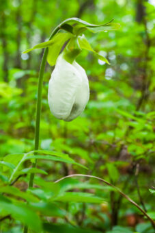
What I wanted: To find and photograph a remote waterfall

I did not know the exact location of the falls but knew the trailhead should be along the rugged dirt/gravel road. Driving carefully down that remote road, I saw a sign for a campsite but found no signage for any trail. Eventually, the road became too rough, so parked and continued on foot. As the road crested the height of land and began to descend, I admitted defeat and returned toward my car.

Knowing the road was parallel to the stream, I attempted a possible bushwack downhill through the woods. As I had very little water with me, I was gambling on reaching the stream. However, the forest proved to be too dense and too difficult … and my water bottle soon ran dry. I again admitted defeat and retreated back up the hill.

Upon driving away and heading back to paved roads, I absent-mindedly left the tailgate open on my car. I only the problem only after attaining the paved road and the noise from behind my head was abnormal. I pulled to the side of the road. My backpack with all my camera gear was missing … it had fallen out the back. Returning to the dirt road and retracing my route, I found my bag in the middle of the road. All was intact – no harm done.

I did not get what I wanted … but I didn’t get lost, didn’t incur injury, and didn’t lose all my gear. Let’s just call that a win.

– Part 3 –

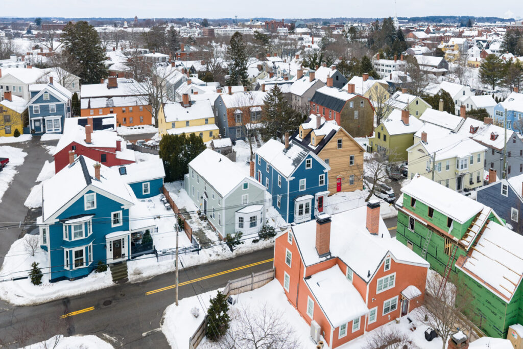
What I wanted: A photo that is both snowy and Christmas-themed. On a snowy mid-December day, I had vaguely planned to travel 1/2 hour and be in the city shortly before dusk.

My plan included camera remote control using an app on a smartphone, but I had recently switched to a new phone. Early afternoon, I tried the remote control without success and this continued least 90 minutes. After numerous online searches and much cursing and screaming, I did achieve success by 3 o’clock. Did I have enough time to get into the city, park, and get in position before dusk? Yes.

At the last possible moment, I decided to abondon my task entirely. First, I was angry and that was not a good frame of being in which to travel. Second, the trip would cost me 90 minutes and I knew that dusk would only last 20 minutes, meaning I would not have sufficient time to relocate and photograph elsewhere. In my mind, a quick cost-benefit analysis ended a depressing result. Although I wanted to make this photograph, it was unlikely to yield financial profit and the trip just wasn’t worth the trouble.

In my life, photography has brought me great joy and satisfaction, but today’s project wasn’t going to do that. I needed peace of mind. As the snow was still falling, I opted for a quiet walk in the woods and did successfully wash away my anger.

Update Regarding Aerial Drones (sUAS) in the U.S. – October 7

I have relied upon an aerial drone for photography and video, for both real-state assignments and publishing projects. Other folks use aerial drones for agriculture, structural (e.g. bridges) assessment, search & rescue, etc.
The dominant provider of commercial and recreational drones has been DJI (a Chinese company) and any alternative providers do not provide the same value at similar price points. Furthermore, we’ve seen multiple companies introducing new applications for aerial drones, including deliveries and transportation.

In the United States, existing uses of aerial drones have faced some disruption in 2025.
(a) Imports of some DJI products have been blocked by US Customs & border protection
(b) Tariffs on imports (notably imports from China)
(c) Pending ban on drones made in specific countries (e.g. China, which includes DJI, Autel Robotics, and others)

The reasons for (a) are muddled but seems a combination of factual bad actors (dating back to 2019) and distrust of specific foreign governments (e.g. China).
The import problem is not directly related to tariffs.

As for (c), the drone ban, this stems from legislation passed by Congress in 2024, which requires the United States government to somehow demonstrate that foreign drones (particularly DJI) are either a threat or not; and if the government fails to do so, then the answer will be assumed to be “threat.” As of October 1, 2025, the government has failed to act or chosen to not act.

If the ban goes into effect (end of this year), there can be several possible consequences.

  1. Imports from specific manufacturers, notably DJI, will be prohibited
  2. Manufacturers such as DJI cannot provide warranty support (including DJI Care) for previously sold products
  3. Unclear if existing drones might be grounded, which would impact hundreds of thousands of businesses including agriculture and law enforcement.
  4. Unclear if the ban might include both commercial uses and recreational uses

Upon reading House amendment to the Senate amendment to H.R. 5009 (Dec.7,2024)

  • * The Secretary of Defense shall fully disassemble a drone aircraft made by DJI or a similar … in order to create a taxonomy for each component
  • * Secretary of Defense shall submit … a report

Possibly the Dept. of Defense has begun this effort, but no one has reported any hint that might be true.
The primary concerns are:

  1. Specifically, military uses (and perhaps civil authority uses) must not rely upon (untrusted) foreign sources.
  2. For any drone/sUAS, increase resiliency of supply chain using parts supplied by domestic sources.
    This is anticipating that aerial drones will increase (deliveries, transportation, etc.) and the technology supply chain need be secure.
  3. In particular, the Chinese government reserves the right to seize any information they want from private companies (including DJI and Autel), which gives rise to general concerns of spying, though no one can identify any specific seizure that might pose a threat to the United States.

Today, there is no American drone manufacturer value and price comparable to the market leader, DJI. (Autel Robotics was a potential contender but is also a China-based company and has been greatly hindered since the U.S. government included the company on their list of concerns.)
largely, legitimate commercial drone use has no alternative to DJI. This may suggest a slow transition (not hard cut-off ban) as American companies step up. At the end of 2025, what exactly will happen remains uncertain and remains a concern for numerous commercial uses. In the meantime, several companies have emerged that sell DJI drone clones, presumably licensed by DJI as they are attempting to work around the impeding ban.

Afternoon Paddle on the Ipswich River

For an afternoon paddle that day, I considered a few options from Middleton to Ipswich. I loaded my canoe atop my car, tied it down, then drove to the boat launch at High Street.

Having paddled here a few times before, I knew well that a wrong turn can easily lead down the Beverly-Wenham Canal.  After using a maps app on my smartphone to double-check my orientation, I stowed the phone in a dry bag and then pushed off, heading upstream.

After beginning my trip with a single-blade canoe paddle, I switched to a double-blade kayak paddle when the canoe paddle struck the river bottom. A double-blade paddle requires less water depth but also requires five or six feet width.  The river is generally quite wide from Middleton to Ipswich.

The current of the Ipswich River can be strong during high water.  Today, the current was slow and this was no surprise.  Up-river in North Reading, a depth gauge had shown less than twelve inches.

I came upon a wooden arch bridge over the river.  Built upon concrete piers, this bridge looked quite nice and was high enough to allow any and all paddlers pass beneath.  Yet I could see that both ends of the bridge were intentionally blocked to disallow foot traffic. Pulling my canoe to a stop in some grass, I retrieved a camera from my dry bag and photographed the bridge.

A bit further on, multiple large trees had fallen across the river.  Getting past these obstacles would take some work and I debated continuing on or turning back.  I pressed onward.  After negotiating with a deeply muddy embankment, I pulled the boat ashore, dragged it fifty feet across the grass, taking care to avoid poison ivy, and put back into the river.  At a different tree across the river, I pulled alongside the log, climbed out, and muscled the canoe over.

At an automobile bridge over the river, a couple stood at the rail to enjoy the river.  I paddled under the bridge and then checked my smartphone to know the exact road. Rowley Bridge Road – my turn-around point.  I thought of friends who lived nearby, but the daylight was waning and I did not have time to go visit them.

The return trip downstream was a bit faster than paddling upstream. But of course I had to again navigate around the downed trees.

Cherry Tree Identification

Once again, I’ve been chasing cherry blossoms. This year I have given more attention to distinguishing different species of cherry trees. The number of hybrids is rather dizzying but I have been focusing on those that I have seen up close in the northeast United States.

In Boston, the Charles River Esplanade is great place to find cherry trees but I could only recognize some of the different trees. This photo shows one of the trees about which I was very uncertain. Having vaguely guessed it is a Mount Fuji Cherry, my photographs revealed a clue that sealed the deal. The leaves are not merely serrated, but it is exaggerated into projections that look like hairs. That is certainly a Mount Fuji.

That tree has now shed its blossoms. Right now the Kwanzan Cherry trees have bloomed and taken center stage. As a very popular ornamental tree, you can find them in many places in every northeastern state. And don’t forget the crabapple trees and flowering dogwoods which have also bloomed in the past week and are putting on a really colorful show!

Seasons Of The Year in New England

Seasons Of The Year in New England

Stick Season

When branches are bare and snow is rare … that’s stick season.
As nature turns grey and quiet, it’s the worst time of year for nature photographers.

Ski Season

When temperatures will allow snow on the ground … that’s ski season.
In northern New England. ski resorts (with snow-making equipment) will typically open in November and close in April.

Love It Or Leave It (a.k.a. Winter)

When natural snow falls and often hangs around for a while … that’s winter.
While many people enjoy winter activities such as skiing, snowmobile … many New Englanders dream of sipping cocktails at a tropical beach far away.

Mud Season

When wet soil can suck the boot off your foot … that’s mud season.
Late March to early May (possibly until Memorial Day), trails may be closed to hikers, ATVs, off-road bicyclists, and cross-country skiers. The Green Mtn Club annually suggests that people avoid trails during mud season because oversaturated soil is vulnerable to both soil compaction and erosion.

Flower Season

When a flowerless world begins to flower, when trees put on a new coat of leaves … that’s springtime.
Crocus can emerge when snow still lies on the ground. When daffodils bloom, then we know all others are soon to follow.
Different species will begin blooming at different times, most from mid April through June.

Flowering-Tree season

When flowers adorn the treetops … that’s flowering tree season.
Around southwest Connecticut, Magnolia can flower in late March. Then flowering cherry trees; then crabapple.
Around northern New England, Dogwood ends the season around the start of June.

Beach Season (a.k.a. Summer)

When people go to the beach and lie in the sun … that’s summer.
Animals roam and browse freely; people roam too, with their warm coats stowed away in closets.

Lobster Season

When lobsters are most active and most abundant … that’s lobster season.
Though lobster fishing is active year-round, peak catch is between late June and late December.

Dog Days

When temperatures are sweltering … that’s Dog Days
Late July to mid August; “dog” days coincides with the year’s heliacal rising of Sirius (in constellation Canis Majoris).

Foliage season

When green treetops are replaced by other colors … that’s autumn foliage
“The reason I far prefer the autumn to the spring is because in autumn one looks up to heaven – in spring at the earth.” Soren Kierkegaard.

And of course …

“When the world seems to shine like you’ve had too much wine … that’s amore.”

The biggest St. Patrick’s Day parades across North America

The biggest St. Patrick’s Day parades across North America

If one of these parades is located near to you, that is likely the definitive parade to you. Yet there are a more than a dozen notable annual St. Patrick’s Day parades in North America. Biggest can mean size of the crowd or number of participants. Photos here are from South Boston.

St Patrick's day parade South Boston

In the USA

Boston MA
Chicago IL
Cleveland OH
Denver CO
Detroit MI
Holyoke MA
Kansas City MO
New Orleans LA
New York City
Philadelphia PA
Pittsburgh PA
Quad cities/Davenport IA
San Francisco CA
Savanah GA

Canada

Quebec City
Montreal
Toronto

Soon … the Next Professional Aerial Camera Drone from DJI

October 2024, while I was awaiting the next generation professional camera drone in the Mavic series, DJI instead released the Air 3S, which is considered a “travel drone” because of its size and excellent portability. The long-anticipated Mavic 4 pro is now expected to be released in April 2025. We know that the Mavic 4 is imminent because DJI submitted the product plan with the FCC. And currently, DJI has offered sale pricing for Mavic 3, which likely indicates DJI wants to reduce inventory of the old Mavic in advance of releasing the new Mavic 4.

Rumored features of DJI Mavic 4 pro

  1. Three cameras (similar to Mavic 3 pro)
  2. 100-megapixel camera resolution
  3. Video resolution up to 6K @ 60fps
  4. Built-in ND filters
  5. Obstacle avoidance includes LiDAR
  6. 6645 mAh battery
  7. Up to 50-minutes of flight on a single battery
  8. Approximate weight 2.3 lbs (a few ounces more than Mavic 3 pro)

Personally, any aerial drone is a flying camera; I’m always hoping for a better camera. However, I do not currently have a need for 6K video resolution. Beyond that, there are a few features here that would immediately render the Mavic 4 pro as “best in class” aerial camera drone ….

Longer flight time is generally welcomed by everyone. The battery capacity is always an important factor in flight time. Because a larger-capacity battery is commonly a heavier battery, achieving longer flight times is a balancing act and more than a small feat.

Built-in ND filters would be very significant. Today, without this feature, we have to land an aerial drone to physically change the ND filter.

LiDAR is important for obstacle avoidance in low light. I’ve seen one report that LiDAR maybe was planned but subsequently cancelled for Mavic 4; which means nobody knows for certain. The Air 3S is DJI’s first drone to employ LiDAR (for forward-sensing only).

Do not confuse DJI Mavic 4 with DJI Matrice 4. Matrice 4 (released earlier this month) is an enterprise class drone that supports thermal imaging, optional spotlight, and can carry payloads up to 200 g.

December Morning in Newport RI

December Morning in Newport RI

7:00 a.m. …. From my hotel room window, the harbor is awash in pastel hues of pink and blue.

7:10 a.m. …. A solo paddleboarder glides northward across the inner harbor, toward Bowen’s wharf.
Morning sunlight hits the top of the 400-ft-tall Claiborne Pell Bridge.

7:20 a.m …. A fishing boat glides south, then turns west between Newport Harbor island and Fort Adams;
then passing Fort Adams, turns south again toward the open sea.

7:25 a.m. …. Fort Adams & houses on Aquidneck Island catching direct warm light of the rising sun 

7:40 a.m. …. The outside air temp is 26f while the temp back home is 16f

8:15 a.m. …. Coffee & peach-raspberry scone

8:40 a.m. …. Walking through a residential neighborhood, a pair of DPW workers fill a pothole with asphalt